

Alaska is a state with incredible natural beauty and a rich cultural legacy, yet its rugged coastlines are also home to mysteries.
A multitude of petroglyphs, or prehistoric carvings that provide insight into the lives of the native people who lived in this area for ages, may be found along its extensive shoreline.
Come us as we investigate the untold tales of Alaska that are buried beneath the fine lines of its shoreline etched in petroglyphs.
Wrangell: The Mystical Petroglyphs of Alaska’s Coastal Wonders
At Wrangell, an island hamlet located in Alaska’s Inside Passage—an archipelago that cascades down the southeast coast of the state like a chain of pearls—water laps softly on the rocky shores of Petroglyph Beach State Historic Site.
In late August, on a bright summer morning, the water has already receded, revealing a rocky paradise that is just waiting to be discovered.
Searching for the numerous petroglyphs that are scattered across the bedrock and rocks along the coastline, as opposed to most beaches where people go to search for seashells or sea glass.
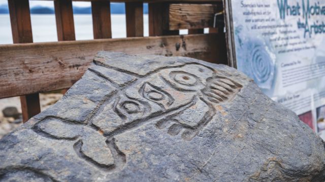
The Tlingit, an Alaska Native tribe that still resides in the state’s southeast archipelago, are thought to have carved the more than 40 rock carvings here, making it one of the highest known concentrations of petroglyphs in Alaska and the world.
Archaeologists generally agree on this theory. The intended meaning of the petroglyphs, however, is still a mystery.
Purposes of Petroglyphs
A placard at the entrance to the beach states that the petroglyphs may have been used for a variety of purposes, such as underwater beacons to entice salmon to swim to the mouths of the rivers and streams that feed into the Inside Passage straits, historical records marking an important event, such as a battle or an epic tidal wave, or territorial markers to warn enemies that they were encroaching on settled land.
Some people think the drawings identify a significant fishing place or village.
“These specific symbols are very unique to Southeastern Alaska,” Nicholas Schmuck, a special projects archaeologist with the Alaska Department of Natural Resources states. “Every time you get a good storm, they can become buried and then later exposed. They also come and go with the tides, causing them to disappear and reappear.”
Later, It Became a National Park
The several-acre location was formally designated as a state park in 2000. A wooden boardwalk winds down onto the rocky coastline, providing access to the petroglyphs.
The petroglyphs are hidden when the tide is in, making the site appear to be just another beach in the vicinity. But when the water recedes, finding the pictures becomes more like an Easter egg hunt, with each piece of art appearing out of nowhere.
The forty petroglyphs that are currently visible at the beach may originally have been more, but they were probably washed away over the years by tides.
You May Also Read:
- Why This Popular Florida Beach is One of the State’s Most Dangerous
- Before You Swim in Palm Beach, Florida – Know This Hidden Danger
- Hidden Gems: California’s Most Underrated Beach Towns for a Peaceful Escape
Best Time to Watch
Use the National Oceanic and Atmospheric Administration’s local tide tables as a guide; low tide is the ideal time to view the petroglyphs.
It’s crucial to remember that the Alaska Historic Preservation Act protects the artworks, and that harming or stealing the petroglyphs is illegal.
Via: smithsonianmag.com
Leave a Reply