The Northeast will bake in heat that will flirt with daily records as the week ends on Friday, followed by more hot and humid weather early next week before some much-needed relief arrives.
– Friday afternoon highs in the mid to upper 90s are expected along the Interstate 95 corridor from southern New England to Virginia. Parts of upstate New York and northern New England may remain in the upper 70s or 80s.
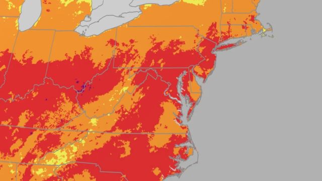
– As shown in the graph below, some locations along the Interstate 95 corridor will approach record highs on July 25.
– Along with the heat, more humid air will move in, causing heat indices to rise above 100 degrees along the I-95 corridor. The National Weather Service has issued heat advisories and extreme heat warnings.
– Strong to severe storms are also possible from Boston to New York City and Philadelphia in the afternoon. Any severe storms would pose the most serious threat, with strong, damaging wind gusts.
– Heat is the leading cause of death in the United States, claiming hundreds of lives each year.
– The combination of heat and humidity is dangerous for those who do not have access to air conditioning, particularly in the heart of major cities.
– Check in on family members, friends, the elderly, and people with chronic illnesses who do not have access to air conditioning.
– If possible, avoid spending too much time outside in the afternoon heat.
– If not, take frequent breaks, avoid strenuous activity, drink more water than usual, and dress loosely and lightweight.
How long will it last?
– Heat relief will be available this weekend along the I-95 corridor from New York to New England, including cooler temperatures and less humid air, especially on Saturday.
– This weekend will bring only minor relief to the mid-Atlantic region. High temperatures will be 5 to 10 degrees lower. Any slight reduction in mugginess on Saturday will be replaced by a more oppressively humid air mass on Sunday.
– It will become hot again in the first half of next week, before a stronger cold front passes through, bringing cooler relief to the Northeast from north to south in the middle to late week. Lower humidity and highs in the 70s and low 80s are expected in the Midwest and Northeast as cooler air moves east Tuesday through Thursday.