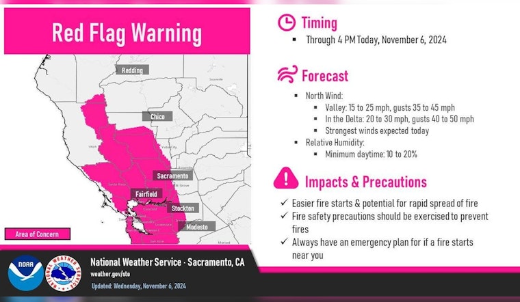
Residents in the Sacramento area are advised to stay vigilant as critical fire weather conditions continue to pose threats due to the combination of gusty north winds and dry air. The National Weather Service in Sacramento, CA, has steadily kept a finger on the pulse of changing weather patterns, signaling a Red Flag Warning that is in effect until 4 PM PST this afternoon for several regions, including the Delta and parts of the Central Valley.
The forecast paints a clear picture of the day’s potential dangers. North winds have been recorded gusting at a brisk 25 to 40 mph and are expected to remain strong through midday. Areas through the Delta may experience more severe gusts, potentially topping out at about 50 mph. These conditions are more than enough to quickly spread wildfires, should they ignite, and the NWS warns of a limited recovery of humidity during the night.
However, towards the end of the week, a shift in weather patterns promises some reprieve as the NWS forecasts “lessening winds” and “generally stagnant and seasonable temperatures.” By the weekend, a slight chill could hit Northern California with a slight chance for “isolated to scattered showers” in certain locales, albeit the probability of significant precipitation lingers at a modest 20% to 40%.
Going into the next week, there is to be a more notable change. The NWS anticipates widespread rain and mountain snow as an elongated upper trough moves through interior Northern California on Sunday. The system, which could bring 1 to 2 feet of snow to higher elevations of the Sierra Nevada, is expected to provide some relief to the drought-stricken region. However, forecasters are cautiously monitoring models that are split over the weather’s progression. The Extended Discussion highlights lingering uncertainties into midweek, with two possible scenarios: either strong upper ridging or further short waves moving through Northern California, leaving questions about the calm after the storm.
Traveling and outdoor activities, particularly aviation, are directly impacted by these conditions. The NWS advises “VFR conditions over interior NorCal next 24 hrs.” Additionally, a Wind Advisory remains in place until this evening for several areas, including the Central Sacramento Valley and Southern Sacramento Valley, among others. Those in these regions should take extra care and prepare for strong northerly surface winds, which could distinctly alter the usual flight paths or outdoor plans.
Note: Thank you for visiting our website! We strive to keep you informed with the latest updates based on expected timelines, although please note that we are not affiliated with any official bodies. Our team is committed to ensuring accuracy and transparency in our reporting, verifying all information before publication. We aim to bring you reliable news, and if you have any questions or concerns about our content, feel free to reach out to us via email. We appreciate your trust and support!


Leave a Reply